In the rolling farm country of north-central Illinois, between the towns of Utica and Ottawa, the Illinois River has carved a stretch of canyon landscape so beautiful and surprising that it is consistently the most visited state park in Illinois. Starved Rock State Park takes its name from a dramatic sandstone butte rising above the river, and the park surrounding it contains 18 canyons, dozens of waterfalls, more than 13 miles of trails, and scenery that visitors from across the country come to experience. If you think Illinois is flat and featureless, Starved Rock will change your mind completely.
The Canyons and Waterfalls
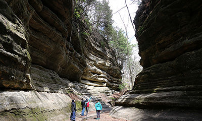
The defining features of Starved Rock are its St. Peter sandstone canyons, carved over centuries by tributary streams cutting down to the Illinois River through ancient rock. The canyon walls rise 40 to 60 feet on either side of narrow gorges, their faces marked by horizontal layers of rock stained in shades of orange, tan, and brown. Ferns and mosses cling to the moist canyon walls, and in some of the deeper canyons, the rock has been sculpted into overhanging alcoves and sheltered chambers that feel almost like being indoors.
Most of the park’s canyons contain waterfalls that flow year-round, though they are most powerful in spring after snowmelt and rain, and most dramatically beautiful in winter when they freeze into hanging curtains of ice. French Canyon, one of the most popular and most photographed, features a tall, narrow waterfall dropping into a mossy basin framed by sheer sandstone walls. Aurora Canyon, Wildcat Canyon, and St. Louis Canyon are among the other standout destinations. The waterfalls at Starved Rock have an intimate quality: you’re not watching them from a distance but standing close enough to feel the mist, surrounded by the canyon walls that amplify their sound.
The Rock Itself and Native American History
Starved Rock, the distinctive sandstone butte for which the park is named, rises about 125 feet above the Illinois River and was once the site of a French fort, Fort St. Louis, built in 1682 by explorer Rene-Robert Cavelier, Sieur de La Salle. The fort was the center of a large Illinois Confederacy settlement and played a significant role in early French colonial efforts in North America. After the French period ended, the rock became associated with a legendary Native American battle in which members of the Illinois tribe were besieged on the butte by their enemies and starved, giving the landmark its name.
Climbing to the top of Starved Rock itself via the maintained trail provides outstanding views up and down the Illinois River valley and gives you a tangible connection to the centuries of history that unfolded here. Interpretive signs along the trail and at the summit explain the fort, the Native American history, and the geological story of the rock.
Hiking the Trails
The park has more than 13 miles of trails ranging from easy river-level walks to moderately hilly routes connecting multiple canyons. The main canyon trail system leaves from the visitor center and provides access to the most popular canyon destinations. Most of the individual canyon trails are short, just half a mile to a mile in length, but they can be combined into longer loops that cover multiple canyons in a single outing. The East Side Trails provide access to a different set of canyons and tend to be less crowded than the main canyon area.
The Illinois Waterway Visitor Center, located adjacent to Starved Rock Lock and Dam on the river, offers a different perspective on the park’s landscape and the managed river system. Watching a recreational boat lock through from the observation deck is a pleasantly diverting addition to a park visit.
The Lodge and Facilities
Starved Rock State Park has one of the finest lodge facilities in the Illinois state park system. Starved Rock Lodge, built by the Civilian Conservation Corps in the 1930s, is a handsome log and stone building that sits near the main trail complex. The lodge has a full-service restaurant, a lodge bar with a stone fireplace, and a variety of accommodation types including lodge rooms, modern cabins, and glamping tents. Staying at the lodge puts you inside the park for morning and evening hikes when the day-trippers have left, which is by far the finest way to experience Starved Rock. The restaurant is quite good and reasonably priced, and the dining room’s rustic atmosphere makes for a memorable meal after a day on the trails.
Seasonal Highlights
Spring, from late March through May, is arguably the best season at Starved Rock. The waterfalls are running strong from snowmelt, the wildflowers are blooming in the canyon floors, and the forest is brightening with new leaf growth. Summer is the busiest period; visiting on a weekday or arriving early on weekends allows you to enjoy the canyons before the crowds peak. Fall brings excellent foliage color, typically peaking in mid-October. Winter, when the waterfalls freeze and snow coats the canyon rims, is the most visually dramatic season and is increasingly popular with photographers and adventurous hikers willing to layer up.
Getting There
Starved Rock State Park is located about 95 miles southwest of Chicago along Illinois Route 178, just south of Utica. It’s an easy two-hour drive from the city and can be done as a long day trip or a weekend getaway. Metra rail service connects Chicago to Ottawa via the Rock Island District line, and the park is accessible from Ottawa by shuttle during certain seasons. Parking at the main lot near the lodge can fill on busy weekends; arriving before 9 a.m. or after 4 p.m. helps avoid the worst congestion.
Starved Rock State Park is one of those Illinois destinations that consistently exceeds the expectations of visitors who come expecting flat cornfields and find themselves instead in a landscape of sandstone canyons, rushing waterfalls, and quiet forest. It’s one of the great natural treasures of the Midwest, and it deserves to be far better known outside the state. Go and see for yourself.